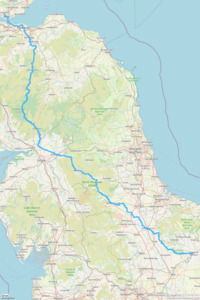
LEL: Dunfermline - Malton
Located in United Kingdom
Approx 2022 route! Part 3
Surface type: 100% road
Traffic levels: 100% Quiet roads
388km long 5249 metres of climbing 28hrs49 at 13.5kmh-
Edinburgh city centre This is a town/village 28 km from start 20m above sea level 2hrs02 at 13.7kmh

-
St Ronan's School, Innerleithen This is an amenity 81 km from start 150m above sea level 6hrs00 at 13.5kmh Official control

-
Mountbenger This is a town/village 94 km from start 285m above sea level 7hrs01 at 13.4kmh Just a pub?

-
Eskdalemuir Community Hub This is an amenity 121 km from start 330m above sea level 8hrs58 at 13.4kmh Official control

-
Langholm This is a town/village 142 km from start 133m above sea level 10hrs29 at 13.5kmh Cafes, shops

-
William Howard School, Brampton This is an amenity 189 km from start 56m above sea level 13hrs52 at 13.6kmh Official control

-
Alston This is a town/village 225 km from start 356m above sea level 16hrs36 at 13.5kmh Cafes, pub, Co-op

-
Killhope Cross This is a viewpoint 229 km from start 490m above sea level 16hrs59 at 13.5kmh

-
The Chatterbox Cafe This is a cafe 241 km from start 303m above sea level 17hrs52 at 13.5kmh In the village hall

-
Barnard Castle School This is an amenity 272 km from start 199m above sea level 20hrs16 at 13.4kmh Official control

-
Barton Park services This is an amenity 301 km from start 102m above sea level 22hrs22 at 13.5kmh Cafe, convenience store

-
Malton School This is an amenity 384 km from start 122m above sea level 28hrs32 at 13.5kmh Official control

Download: Route card
Packages: London-Edinburgh-London 2022
 Home
Walking
Regions
Packages
Routes
Dot-watcher
Login
Sign up

