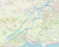
3Down modified 2023
Located in United Kingdom
Note that this is a modified route that uses A roads between Maidenhead and Pangbourne. It does still go through all the controls, of course. The most significant climb is the White Horse Hill Climb, which is a 1.2-mile climb with an average gradient of 6.6%. There are also several other smaller climbs throughout the route.
https://www.audax.uk/event-details/9983-3down_london___new_forest
Surface type: 100% road
Traffic levels: 77% Quiet roads 23% Busy / main roads
306km long 1674 metres of climbing 21hrs20 at 14.4kmh-
Hare Hatch This is a town/village 22 km from start 61m above sea level 1hrs30 at 14.5kmh

-
Pangbourne This is a town/village 42 km from start 41m above sea level 2hrs53 at 14.5kmh CONTROL

-
Aldermaston This is a town/village 55 km from start 56m above sea level 3hrs45 at 14.6kmh

-
Kingsclere This is a town/village 70 km from start 167m above sea level 4hrs52 at 14.4kmh Honesty has cakes, coffee

-
Whitchurch This is a town/village 79 km from start 113m above sea level 5hrs29 at 14.4kmh Food & coffee shops

-
Longstock This is a cafe 96 km from start 80m above sea level 6hrs39 at 14.4kmh CONTROL

-
Into the New Forest This is a wildlife scene 129 km from start 84m above sea level 8hrs59 at 14.3kmh

-
Crendell This is an amenity 148 km from start 69m above sea level 10hrs18 at 14.4kmh INFO CONTROL - on L at Junction

-
Fordingbridge This is a town/village 159 km from start 32m above sea level 11hrs03 at 14.4kmh CONTROL, Co-op + others

-
Linwood This is an amenity 165 km from start 55m above sea level 11hrs28 at 14.4kmh INFO CONTROL on R opp Pub

-
Sparsholt This is a shop 208 km from start 87m above sea level 14hrs30 at 14.3kmh INFO CONTROL on R opp bus shelter; Village shop here

-
Alresford This is a town/village 227 km from start 104m above sea level 15hrs48 at 14.4kmh CONTROL, Co-op, coffee shops

-
Overlooking Basingstoke This is a viewpoint 242 km from start 127m above sea level 16hrs53 at 14.3kmh

-
Riseley This is a town/village 264 km from start 72m above sea level 18hrs25 at 14.3kmh Few shops

-
Winnersh This is a town/village 281 km from start 40m above sea level 19hrs35 at 14.3kmh CONTROL, Supermarkets

-
Maidenhead This is a town/village 297 km from start 58m above sea level 20hrs40 at 14.4kmh Shops to west of Thames

-
Beaconsfield Services This is a town/village 311 km from start 95m above sea level 20hrs44 at 15.0kmh Arrivée

Download: Route card
Packages:
 Home
Walking
Regions
Packages
Routes
Dot-watcher
Login
Sign up

